- Language -
 Introduction
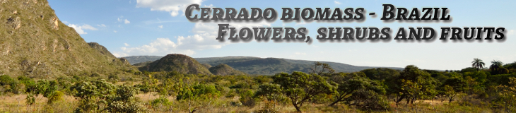
 The Cerrado has a type of vegetation composing brazilian phytogeography and it is also the second most important vegetation cover of the country (occupies 24% of the national territory), surpassed only by the Amazon rainforest.
It is extended over eleven States of Brazil and also in the Federal District; it is considered as the cradle of the waters of the country.
However, its surface has deeply decreased along the years width the human intervention.
The region of Cerrado has a tropical climate with two well defined seasons (which can be modified by climatic changes):
* a rainy period (October till April),
* another dry one, from May till September.
It covers the states of the Central-West region of Brazil like the State of Goiás, the State of Mato Grosso, the States of Mato Grosso do Sul and of Distrito Federal, as well as the southern states of Pará and Maranhão, the interior of Tocantins, part of the west of the State of Bahia, as well as the three-quarters of the State of Minas Gerais (western part of the Cordillera do Espinhasse) and the northern of the State of São Paulo.
A vegetation consisting, in principle, by species that adapt to the two distinct seasons (as occurs in the Midwest), deciduous and with deep roots (and small, with twisted branches and thick sheets).
The Cerrado comprises various characteristics of vegetation, being, that way, classified into sub systems:
field, cerrado, nativ cerrado, forests, riparian forests of streams, paths, and wetland environments, etc.
In general, the grounds are poor and very acid.

The various landscapes of Cerrado.
Some photos are available to show the regions enclosed in the area covered by the biomass Cerrado, but we only present here the places with particularities or the beauty of nature.
A great part of the country is constituted of a mountainous relief crossed by valleys with streams or more or less important rivers.
This part of Brazil is considered the center of waters of the country.
Hence, many rivers (Tocantins, etc) will descend by the north, or the east to irrigate regions and states (Click on the image above).

 In order to better discover the regions of Cerrado presented here, follow this link
The Cordillera of Espinhass.
(State of Minas Gerais to the south and Bahia to the north)
(State of Minas Gerais to the south and Bahia to the north)
Photographs are proposed to show some regions forming part of the Cerrado bioma area, but only places known for their geological or environmental or tourist "specificities" are presented here. Most of the country is made up of mountainous terrain (plateaus and valleys) crossed by more or less important streams or rivers. The central part is considered the water basin of Brazil. From these places several large rivers are born (Araguaia, Tocantins, São Francisco, etc.) which will irrigate regions and states towards the north or east.

-- Documentation --


Cerrado biomass - Expo of photographs
***Plants of the Cerrado's biomass ...***Composition of photographs***Reflection and water transparency ...***Odd met ...Other context - Maritime environment
***The coast of the Nordeste region in Brazil - Visit